Tag Archives: John Boyd Macdonald

Jack the Rammer

Jack the Rammer

Jack the Rammer Click to view larger image

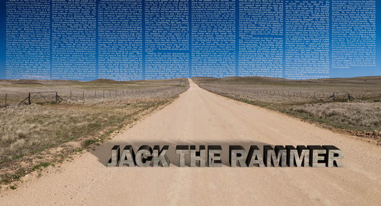
The Bushranger is an iconic figure in the mythology of colonial Australia. They still appeal to our sense of national self-identity because we see them as being brave, independent, charismatic, anti-authoritarian, and resourceful. Underdogs, tragic heroes. Just like we’d like to imagine ourselves to be. The reality is that most lived pretty sordid and short lives, and were often quite unpleasant and disloyal in their personal affairs – more ‘squalid hood’ than ‘Robin Hood’.

Bushrangers were active in the Monaro region during two periods of the 19th Century. Firstly during the late 1820s and ’30s, when most were escaped convicts, and then again around the early 1860s while the gold rushes were in full swing at places such as Kiandra and Araluen. For a few months at the end of 1834 “Jack the Rammer”, along with fellow gang members Edward Boyd and Joseph Keys, ranged across the Monaro. Jack the Rammer, a.k.a. “Billy the Rammer”, is believed to have been William Roberts, who was transported in 1833 from Dudley his native Worcestershire after being convicted for stealing a bucket.

(A personal coincidence here: my great-grandfather William Rial was born a short way from Dudley in the village of Hallow, and was himself transported in 1835, and assigned to work at Wanniassa station, just to the north of the Monaro).

After escaping with Joseph Keys from Goulburn Jail in September 1834, Roberts and Keys joined up with Boyd, and the three began a series of nocturnal robberies on stations of the Monaro, including Coolringdon, 10km southwest of Cooma. In the course of holding up Rock Flat station in mid December, The Rammer was shot and killed by the station overseer Charles Fisher, who was himself shot, beaten and left for dead by the other two outlaws. Boyd was shot dead by a trooper in mid-January while trying to escape across the Snowy River, and Keys was captured two days later at Jimenbuen, tried and hung in June 1835. Like many bushrangers, the gang had a short, bloody and spectacularly unsuccessful career.

The base photograph for this image was taken on the Springfield Road, not far from Coopers Lake, not too far south of where ‘The Rammer’ met his end. The newspaper text (from the Christchurch Star, 8 April 1879) is a lurid account of the exploits and demise of the Rammer Gang.

Railway

Railway

Railway Click to view larger image

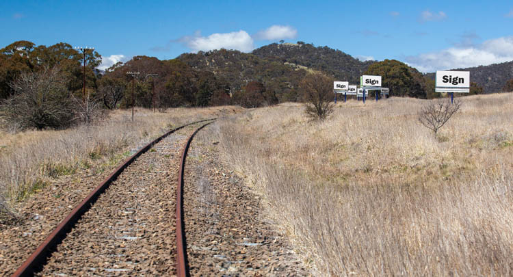
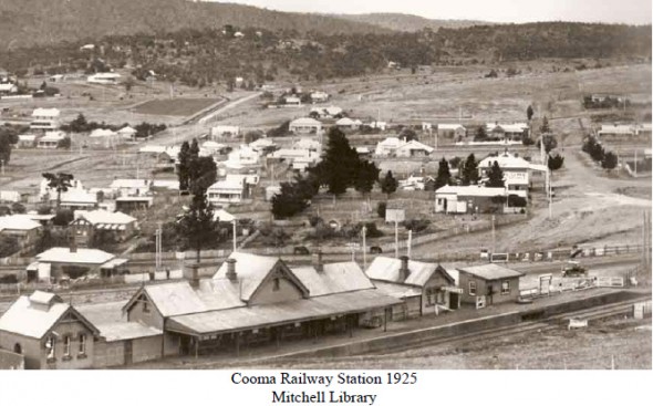
Even before the time that the railway reached Goulburn in 1869, there were calls for the line to be extended into the Monaro. The line to Cooma (through Queanbeyan, Michelago, Bredbo and Bunyan) was eventually opened in 1889, with later extensions through to Nimmitabel (1911) and Bombala (1921).

The arrival of the railway had a huge social and economic impact, and really served to ‘open up’ the region to the outside world. However, despite a boom during the construction of the Snowy Scheme, when Cooma was the base of operations, the line always ran at a loss. (One justification for the railway had been that it would allow for shipment of wheat grown in the Monaro to other markets – but it had quite the opposite effect, with the marginal Monaro grain unable to compete with the cheaper wheat that could now be shipped in from other regions.)

Cooma Railway Station 1925

The line closed in 1988 – exactly one hundred years after its establishment. The billboard signs now have no rail passengers to talk to (though they still ‘serve’ the adjacent highway traffic).

We tend to look at billboards in terms of the messages they display, rather than as large constructions plonked onto the landscape. They (almost) never draw attention to themselves as objects. We are so accustomed to their presence as we travel that we don’t really take notice of their physicality either.

In this image, a scene along the closed Cooma rail line, the signs have nothing to say about fast food outlets, ski resorts or car repairs. Their only function is to declare their own ‘sign-ness’.

Robinson-Smithson

Robinson-Smithson

Robinson-Smithson Click to view larger image

George Augustus Robinson (1791-1866) was a key figure in the story of relations between European and Aboriginal Australians in the 19th Century. He arrived in Hobart in 1824, and from 1829 to 1834 he undertook a number of journeys around Tasmania, ‘persuading’ the indigenous people to move to settlements in Bass Strait, ultimately settling on Flinders Island. He was personally responsible for the Flinders Island settlement from 1836-39.

As described in the Australian Dictionary of Biography, “he first set out to provide adequate food supplies and to improve housing; but his greatest change was to root out Aboriginal culture and to attempt its replacement with a nineteenth century peasant culture.” (http://adb.anu.edu.au/biography/robinson-george-augustus-2596)
We now know the outcomes of that project. He presided (if unintentionally) over a tragedy in Tasmania, and is now a figure of some controversy – whatever his intentions. Described by some as a ‘Victorian do-gooder’, he was very much a person of his time.

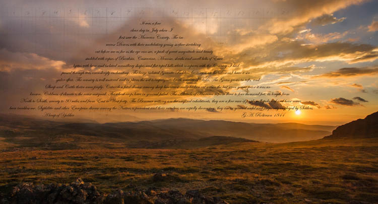
From 1839-49, he was ‘Chief Protector of Aborigines’ for the Port Phillip District, during the course of which time he travelled widely, including an 1844 journey up through Gippsland and across the Monaro. The text in this image is an extract from his official report on those travels. In it he records that:

It was a fine clear day in July when I first saw the Maneroo County. The immense Downs with their undulating grassy surface stretching out before me as far as the eye can see, a park of great magnitude and beauty studded with copses of Banksia, Casuarina, Mimosa, shrubs and small belts of Eucalyptus with bare and isolated mamillary shapes and flat toped hills which compares with the Country I had passed through was exceedingly enchanting. The large isolated Granite Bolders (common on the Downs) have a singular effect. The country is well watered and in places the soil is impregnated with munate of Soda. The Grass grows in tufts, and Sheep and Cattle thrive amazingly. Catarrh a fatal disease among sheep has occasionally broken out within the last seven years; prior it was unknown. Coldness of climate is the cause assigned. The wheat crops have in general failed. The Altitude of Maneroo is from three to four thousand feet, its length from North to South, seventy to 80 miles and from East to West forty. The Bimmer mittong are the original inhabitants, they are a fine race of people well spoken of and have never been troublesome. Syphilitic and other European disease among the Natives is prevalent and their numbers are rapidly decreasing: they are in general useful and frequently employed by Settlers.

The American artist Robert Smithson (1938-73) is most well known for his ‘land art’, and for his critical and theoretical writings. In the course this he produced his pencil drawing A Heap of Language (1966), a work of ‘language to be looked at’.

Robert Smithson. A Heap of Language (1966)

Robert Smithson. A Heap of Language (1966)

Because I’ve recently been researching both Robinson and Smithson, it seemed somehow logical to connect the two in this image. In the process Smithson’s ‘Pile of Language’ has become ‘A Pile of Yabber’, forming a new mountain amongst the rolling hills south of Jagungal.

George Augustus Robinson

George Augustus Robinson

George Augustus Robinson Click to view larger image

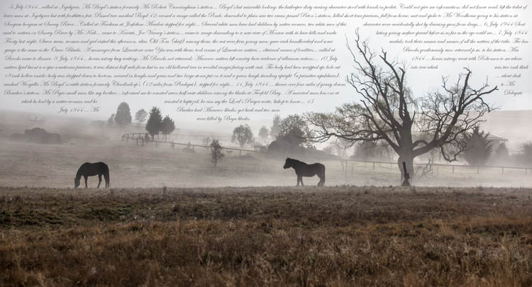
George Augustus Robinson travelled across the Monaro in 1844, in the course of his duties as ‘Chief Protector of Aborigines’ for the Port Phillip District. The journal that he kept during that journey provides some great insights into the lives of the early European settlers , the Ngarigo people whose land they ‘settled on’, and the attitudes of the time.

In the extracts incorporated in this image, he wrote:
5 July1844…called at Injebyrer, Mr Boyd’s station formerly Mr Robert Cunningham’s station… Boyd’s hut miserable looking; the hutkeeper dirty cursing character stood with hands in pocket. Could not give me information; did not know road; left the ticket of leave man at Injebyrer hut with frostbitten feet. Passed tree marked Boyd 42; crossed a range called the Pinch; descended to plain saw two emus; passed Paton’s station, killed short time previous, fall from horse; met and spoke to Mr Woodhouse going to his station at Soogum boogum at Snowy River…Called at Fincham at Jindabine Meadow stopped for night… Several white men have had children by native women, two white men of this character were accidentally shot by drawing guns from drays…

6 July 1944 Sent card to natives on Snowy River by Mr Kirk… came to Karrut, Joe Varney’s station… came to range descending to a new view of Monaro with its bare hills and undulating grassy surface spread before us as far as the eye could see…

7 July 1844 Frosty last night. Seven men, women and girl visited this afternoon, alias Old Tom (chief) among them; the rest were firm young men; gave each handkerchief and some medals; took their names and names of all the natives of the tribe. The language is the same as the Omeo Blacks. A messenger from Limestone near Yas was with them; took census of Limestone natives… obtained names of localities… called at Brooks gentlemanly run; returned p.m. to his station, Mrs Brooks came to dinner.

8 July 1844… horses astray busy writing; Mr Brooks not returned; Maneroo natives left country bare evidence of villainous action;… 10 July 1844 … horses astray; went with Robinson to see where natives had burnt a corpse sometime previous; it was distant half mile from hut in an old hollowed tree in wooded ranges facing south east. The body had been wrapped up; hole cut into tree which was two inch thick 18 inch hollow inside; body was dropped down to bottom, covered in boughs and grass and two large stones put on it and a green bough standing upright (a primitive sepulchre). … about dusk reached Wonjellic Mr Boyd’s cattle station formerly Clendindorp’s (12 miles from Pinchgut), stopped for night…

11 July 1844 … thence over four miles of grassy downs to Mr Boucher’s station; Mr Pryce small man like my brother… informed me he counted seven half caste children among the blacks at Twofold Bay. A married man has one at Delegate which he had by a native woman and he wanted it baptized; he can say the Lord’s Prayer write, bishop to know… 13 July 1844 … Mr Barber had Maneroo blacks; got bark and two men were killed by Bega blacks; Maneroo blacks killed two men Queenbeers sometime ago so Mr Robinson…

He base image was take as the dawn fog was lifting on the outskirts of Dalgety.

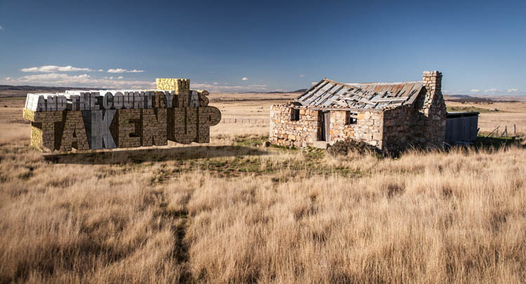
And the Country Was Taken Up

And the Country Was Taken Up

And the Country Was Taken Up Click to view larger image

Kate Grenville tells the story that, when she was in London researching for her novel The Secret River, she had a conversation with writer Melissa Lucashenko. She explained that she was in London looking for information about her ancestor Solomon Wiseman, who “took up land on the Hawkesbury River”.  Lucashenko, who is of mixed European and Murri (Aboriginal) heritage, replied: “What do you mean ‘took up’? He took!”

In Searching for the Secret River (p.28-9), Grenville goes on to distinguish the two expressions:

“Took up: you took up something that was lying around. You took up something that was on offer. You took up hobbies and sports
Took had many more possibilities. You took something because it was there like a coin on the ground. You took offence or flight or a bath. Or you took something away from someone else.”

Writings by and about the squatters, selectors and settlers who moved into the Monaro region from the 1830s onwards frequently refer to them as having ‘taken up’ land. In the early days following European arrival the process was simple. In an 1892 article in the Monaro Mercury Bernard O’Rourke, who arrived in the region in 1834 described how they were guided to suitable land by the local Aboriginal people.

“They ‘would yabber about a big fellow station out there’… and the settlers desirous of increasing their territorial possessions, would implicitly go after them. In the course of a few days or weeks the ‘promised land’ hove into sight, and there the land grabbers pitched their tents and regarded that as ownership of the many acres which appeared to serve as a panacea for their adventures”

In this image I’ve sought to make the notion of ‘taking up’ the land as real and as solid as the homesteads that they built upon it. The ‘text homestead’ hovers a little above the ground, as a little visual pun on ‘taken up’.

The picturesque ruined farmhouse was photographed on the Ironmungy Road south of Dalgety.

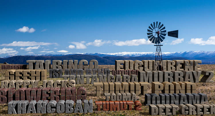
Damn (monumental masonry)

Damn (monumental masonry)

Damn (monumental masonry) Click to view larger image

The Snowy Scheme entailed the construction of some 16 dams across the mountains, ranging in size from the  huge (Eucumbene, with a capacity of nearly five billion cubic metres) to the tiny (Deep Creek, capacity just five thousand cubic metres). Construction took 20 years, with work on the first (Guthega) starting in 1950, and the last (Talbingo) not completed until 1970.

They now form a prominent, perhaps dominant, feature of the mountain landscape, especially seen when flying over the region. They now fill river valleys that were previously home to remote alpine rivers.  Mountain forests, fine farming country (e.g. where the Blowering Dam now sits), whole towns (‘Old’ Adaminaby and ‘Old’ Jindabyne) have been inundated to achieve the goals of the Scheme.

For this image, I’ve put the names of the sixteen onto a hillside looking out to the snow-covered Crackenback and Main Ranges, looking a little like monumental masonry. The windmill suggests an alternative technology for generating power and pumping irrigation waters.

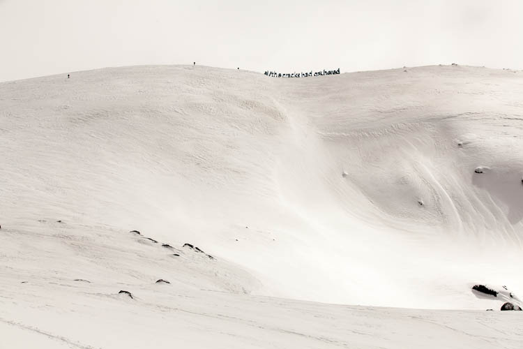
All the cracks had gathered

All the cracks had gathered

All the cracks had gathered Click to view larger image

Since its publication in The Bulletin in April 1890, Banjo Paterson’s The Man From Snowy River  has come to exemplify the kind of bravery and bush skills that Australians like to identify with – even though relatively few have ever lived the kind of bush idyll depicted in the poem. Although one of the most urbanised nations in the world, the image of the rough, resourceful and resilient ‘bushie’ has always been a core part of the national identity.

Few poems have been as well known and popular, and the first verse is probably known by more Australians than any other ‘local’ poetry:

There was movement at the station, for the word had passed around
That the colt from old Regret had got away,
And had joined the wild bush horses – he was worth a thousand pound,
So all the cracks had gathered to the fray.

For many people it’s also been considered to be a story about and set in the ‘High Country’, though apparently Paterson was thinking of the country around present-day Burrinjuck Dam when he wrote it. (Perhaps this should be obvious, as ‘the man from Snowy River’ was an outsider in the poem.

In this image, I’ve taken a couple of liberties with Banjo’s poem. Firstly, favouring popular misconception over geographical accuracy, I’ve set a fragment of the text into the Snowy Mountains, at the summit ridge of Mt Twynam (second only to Kosciuszko in altitude), seen from the northeast side near Little Twynam. And secondly, the ‘cracks’ are not mounted on horseback but on cross-country skis as they near the summit.

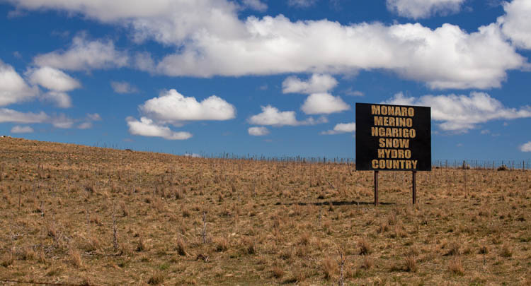
Monaro Merino Ngarigo Snow Hydro

Monaro Merino Ngarigo Snow Hydro Country

Monaro Merino Ngarigo Snow Hydro Click to view larger image

The base photograph for this image was taken on The Arable Road, just at its junction with the Cooma-Jindabyne Road near the Cooma Airport. The ‘real’ sign marks the boundary of the ‘Brookfield Park’ property.

Like the Cooma Welcomes You image, it was inspired by another sign, whose message is “Monaro Merino Country”. I’ve made a few additions to that message (there could have been more) to allow for some alternative designations of the land.