Author Archives: John Boyd Macdonald

Terra nullius

Terra nullius

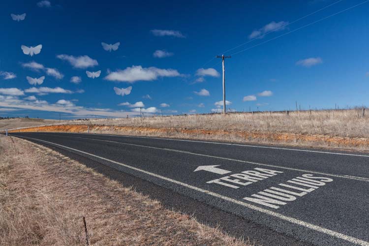
Terra nullius (Click to view a larger image)

This image depicts a section of road between Dalgety and Jindabyne in the Monaro region of NSW. Prior to the arrival of the first European colonists in the 1820s this region was Ngarigo country. They ranged widely over the region, and (along with members of other language groups who lived around the Snowy Mountains) travelled in summer to feast on Bogong Moths amongst the granite boulders of the high country.

As with squatters and settlers in other parts of the colony, the Europeans appropriated the land for their use and instituted a system of land title that ignored any property rights that may have been held by the indigenous people who had lived here for many thousands of years previously. Their right to take ownership in this way was later formalised into the legal doctrine of terra nullius i.e. the principle that the land was vacant prior to their arrival.

In this image I simply wanted to draw attention to this notion (which is no longer recognised by the Australian legal system). However the road’s invitation to move into the ‘unoccupied’ land is symbolically contested by the Bogong Moth cloud shapes which still look down over the land. The diagonal slash of the road is intended to lead the viewer’s eye from the right foreground (and its text), towards the horizon on the left and up into the moth-clouds.

Farm Ridge/Bogong

Farm Ridge tree

Farm Ridge/Bogong Click to view larger image

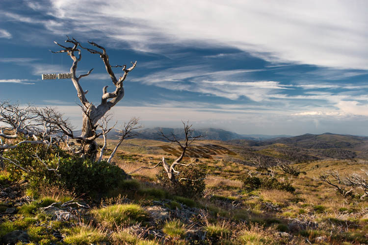
The base photograph for this image was recorded along the now-overgrown Farm Ridge Fire Trail, at the top of a climb up from the Tumut River and several kilometres north of the ruins of the Farm Ridge Hut. It looks south along the ridge towards Mt Jagungal and the Main Range in the far distance.

In this image I wanted to allude to the same issue taken up in another image (Doubtful) – the contested nature of place names in the Snowy Mountains region, and the conflicting narratives which lie underneath the various names in competition.

The Aboriginal visitors to this area (which appears to have never had permanent residents) used different names to denote a place, according to their language group, clan membership, level of initiation into sacred knowledge – and even the season. ‘Jagungal’, the name now applied to the largest mountain of the area, is only one of the names transcribed by early European visitors, who also recorded the name as ‘Targil’, ‘Teangal’, ‘Jar-gan-gil’, ‘Corunal’ and ‘Coruncal’. It is no longer possible to know whether the name ‘Jagungal’ would have been understood by the original inhabitants.

It is certain, however, that ‘Bogong’ was widely used to indicate the places where Bogong Moths could be found during the summer months, the high country places with granite boulders that were destinations for seasonal migration and feasting. Jagungal was referred to as “The Big Bogong”, so as to distinguish it from other destinations such as those now known as Dicky Cooper Bogong, Paddy Rush’s Bogong and Grey Mare Bogong.

The ‘Bogong’ name referred not only to the peak, but also to the surrounding region. The name identified not just a place – but the function and value of the place as well i.e. as country where Bogong Moths may be had.

The European pastoralists who commenced their own seasonal visits to the region in the second half of the 19th century demanded a more precise and detailed set of names for the topographic features and localities of the area, and set about putting their own names onto the landscape. For them, this naming of places was connected with the assertion of ownership; if I know names for all the places in a region, especially if I have myself given them names, then my claim to a legitimate and proprietorial relationship with the place is strengthened.

Like the original inhabitants, the mountain stockmen frequently adopted place names which referred to some story associated with the place (e.g. ‘Pugilistic Creek’) or to the function or value of the area. ‘Farm Ridge’, which runs north from near the foot of Mt Jagungal along the Tumut River, is a name which clearly denotes the area as a place for white Australian agriculture – and no longer as a place for feasting on the Bogong moth. (Though, interestingly, the mountain stockmen who visited and worked in this area up until about 60 years ago would still refer to Jagungal as “The Big Bogong”.

In this Farm Ridge/Bogong image, I have tried to juxtapose these two opposing visions of the mountain scene. The ‘Bogong’ name is depicted as tied more closely to the landscape (through thousands of years of use), with the ‘Farm Ridge’ name tacked on (or suspended from a tree branch) in a more fragile way, reflecting a shallower connection to the land. One interpretation could be that the country ‘knows itself’ as Bogong, but has not (yet) come to identify itself as Farm Ridge.

The interesting thing about both names however (common to many place names) is that neither name reflects the actual current human use of the land. No-one comes to harvest the summer Bogong moths any more, and summer grazing of stock in this region, now designated as the ‘Jagungal Wilderness’ within the Kosciuszko National Park, was stopped decades ago.

However the Bogong Moths still come every summer.

Doubtful

Doubtful Creek

Doubtful (Click to view larger image)

The place names of the Snowy Mountains region have always seemed very special. For me at least, they have a romantic, even magical resonance in their sounds and the feelings that they evoke. Names like ‘Bogong’, ‘Monaro’, ‘Crackenback’, ‘Dead Horse Gap’, ‘Perisher’, ‘The Dargals’, ‘Pugilistic Creek’, ‘Dicky Cooper Bogong’, ‘Sue City’ – they conjure up images and stories of times past, and the various narratives of the Aboriginal peoples, the early European explorers and pastoralists, the workers of the Snowy Mountain Hydro Scheme and the skiers and hikers of modern times.

But the contemporary names, which are now fixed and codified by the Geographic Names Board (for NSW) conceal a history of confusion, change, and contention as European society struggled to impose a set of names onto the landscape which had managed to exist quite satisfactorily without labels on every locality and topographic feature.

There are many difficulties in establishing the names used by the Aboriginal peoples in the Snowy Mountains region (and similar problems in many other places too). The Indigenous naming system was not like that of the Europeans colonists.

There were more than 300 different language groups across the continent prior to European colonisation, and several groups that converged on the Snowy Mountains (especially for the summer Bogong moth migration), probably including speakers of Ngunawal, Ngarigo, Yuin, Walgalu, Bidawal and Jaithmathang languages. So one place may have had different names in different languages. One place (especially rivers) may have had several different names. A name may have been applied to a particular geographic feature as well as to the surrounding region, and some names may have had a secret or sacred dimension, and be known only to particular members of the group. Place names were often used to indicate the value or resources available from that location (‘Bogong’ is probably a good example of this). And further, land and mythology are inextricably related, and place names were often used to access the spirit and ancestor stories about places to which they are attached. (See the Our Languages website for further discussion of indigenous place names.)

When Europeans arrived in the region they generally sought to learn the local names for places from its inhabitants. This attempt was fraught with potential for error, however, for all of the reasons above. In the Monaro and Snowy Mountains regions, it soon became difficult due to the rapid decline in the indigenous population, and the disruption of their culture following the colonial settlers’ appropriation of their land. Also, Aboriginal words were often poorly transcribed into English text, and descriptions of places (e.g. ‘pretty’ or ‘resting place’) could be erroneously recorded as place names. The early European visitors themselves delighted in giving their own new names to places in the Snowy Mountains, blithely unaware of other names that may have been applied by earlier visitors.

A contest of names ensued, which can be also seen as a contest for dominance between the narratives and interests of the groups who supported different names. One result is that it can be quite difficult now to reconstruct the journeys of travellers to the region in the 1800s, as the place names they used may not have been recognised by anyone other than themselves! Our ‘modern’ “Mount Jagungal”, for example, has been variously referred to as ‘Bluff Hill’, ‘Big Bogong’, ‘Targil’, ‘Teangal’, ‘Jar-gan-gil’, ‘Corunal’ and ‘Coruncal’.

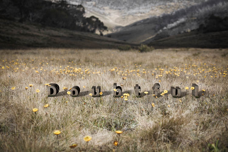
In my Doubtful image, I wanted to allude (perhaps somewhat obliquely) to this state of confusion and the contested history of place names in the region. “The Doubtful” is in fact the ‘official’ name of a real creek near Mt Jagungal. The Geographic Names Board describes it as “a watercourse about 19km long. It rises about 2 km NNW of North Bulls Peak and flows generally N into Tumut River.” For me it has extra significance as it runs adjacent to (my grandfather) Archibald Rial’s hut at Farm Ridge. Family legend has it that he (or his workers) panned the gold for my grandmother’s wedding ring from that creek.

Alan Andrews, in Kosciusko: the Mountain in History (O’Connor, Tabletop Press, 1991) suggests that its name might derive from the surveyor Thomas Townsend’s uncertainty in 1847 as to whether it flowed into the Tumut or Snowy River systems. (I haven’t looked too hard for a more definitive derivation of the name, as I rather like the uncertainty.)

In the Doubtful image, the letters of the word ‘Doubtful’ are not embedded in the landscape but placed on top of it. The letters are widely spaced, and in mixed case so as not to appear overly authoritative. The landscape itself was photographed with very shallow depth of field, to further accentuate the sense of uncertainty.

Behold, my land is before you – Monaro ‘textscape’

Behold, my land is before you. Dwell where it pleases you.

Behold, my land is before you. Dwell where it pleases you. Click to view larger image

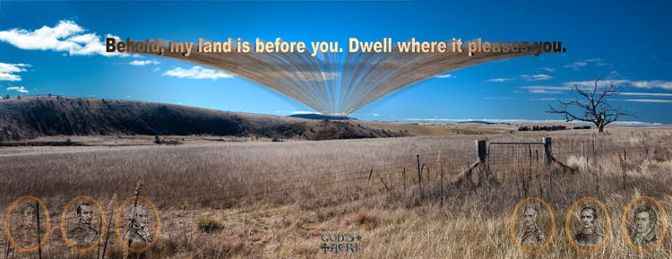
The inclusion of text with this panoramic Monaro landscape image (along the Jindabyne-Dalgety road) fundamentally alters the image. From being simply a view of a specific rural landscape with a fence, a stark bare tree and a distant line of hills (and so largely functioning as representation) it becomes a site for the expression of ideas through symbols. It is generalised and recreated, no longer just one specific paddock but a field of meaning.

The specific text in the image is of biblical origin (Genesis 20:15, as Abraham arrives in the Promised Land), but was selected so as to also invoke a colonial vision of ‘taking up’ the land, with suggestions of terra nullius. The colonial reference is made explicit through the inclusion of a line of portraits of 19th century Governors of NSW – including Bligh, Macquarie, Gipps and the ‘Father of the Wool Industry’ John Macarthur. They look down from on high (in the sky) in a way which is intended to appear half like cameo portraits, half like gods looking down. The small ‘God’s Acre’ logo in the bottom tries to bring together that idea of the appropriation of the land having been undertaken with divine blessing.

The gate and fenceline running across the frame reinforces the notion of appropriation; this land belongs to its pastoralist owner, and is no longer public  or available for other users.

Ten-Mile Stare – Monaro ‘textscape’

Ten-Mile Stare

Ten-Mile Stare

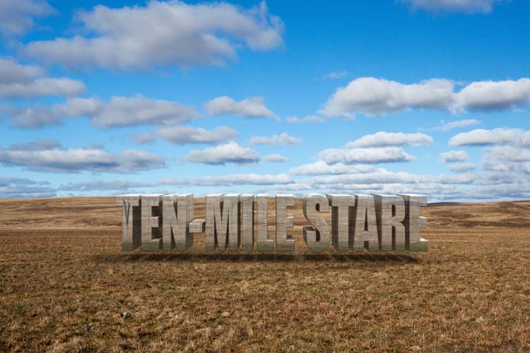
This image has much in common with the previous Willy Gray picture. The base image was taken at the same time and location  (mid-winter 2012 near Dalgety in the Monaro region of NSW). It’s a little more colour-saturated, and although untouched in post-processing, the sky has a slightly unreal feeling to it – almost reminiscent of the opening credits of The Simpsons animation!. Although not photo-stitched to create a panoramic aspect ratio like Willy Gray, it frames a similar composition of cloud-spotted blue sky over a grassy plain (I refrain from calling it a ‘paddock’ or ‘pasture’ so as not to define it by its current function).

The ‘Ten-Mile Stare’ text is also derived from the same David Campbell poem (The Monaro). The full line reads:

“Willy Gray has a ten-mile stare
and his eyes are droving with a dream of sheep
down raddled stock-routes to tread white air”

Like the other Willy Gray image, the intention is to call up the romantic European-Australian squatter/grazier vision of the landscape, projected in three dimensions as a text object on the landscape to which it relates and adheres. The text fragment is however less prescriptive, even somewhat oblique, forcing (or enabling) the viewer to extract their own meaning or interpretation of the image. Alternative interpretations are both possible – and desirable.

Willy Gray – Monaro ‘textscape’

Willy Gray - Monaro 'textscape'

Willy Gray has a lover's eye, and it goes over the twin bare hills and the blond paddocks to the bleached sky

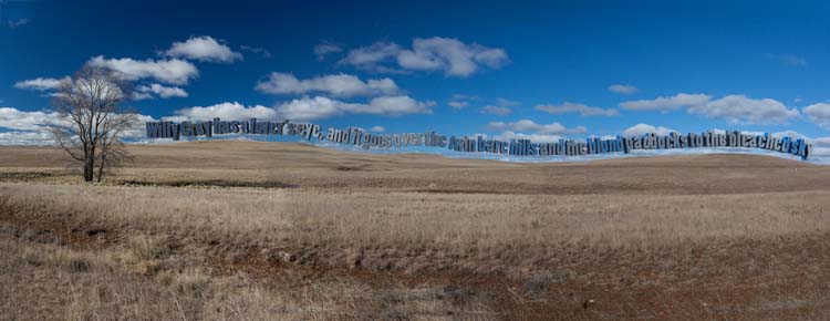
The text incorporated in this Monaro landscape image (three original photographs taken near Dalgety) is from The Monaro – a poem by David Campbell (reproduced in his Collected Poems). The full verse is:

“Willy Gray has a lover’s eye
and it goes over the twin bare hills
and the blond paddocks to the bleached sky
Until it has come to a thought that fills
his mind with tenderness for this wild
upland country and her suckling child”

The panoramic landscape image is a typical winter scene on the Monaro:  Almost treeless, flat to undulating grassland terrain, suggesting human presence only through erosion scars. A long, almost uninterrupted horizon line and big skies. Sheep, dams, buildings, roads and fences are deliberately excluded, though in fact each of these was present just out of the frame. The intention is to present a ‘simple’ landscape, one which may bear close resemblance to the landscape as it was prior to European occupation.

The inclusion of the text floating above the horizon disrupts a straightforward reading of the scene. It informs the viewer that the creator of the image seeks to do something other than simply present a representation or bucolic idealisation of the scene. The viewer is compelled to ‘read’ (quite literally) the image, and to look for meaning or message within it.

In this particular image, the text is intended to function as an analogy for the way in which a European/Australian cultural narrative has been overlaid on the pre-existing, elemental landscape. Not part of the physical landscape, but projected onto it. A landscape and climate which is often difficult for its human inhabitants is described in terms of “tenderness” and viewed with “a lover’s eye”.  It is anthropomorphised, given human attributes by the poet – and by those who share his vision. A maternal, nurturing character is projected onto land which (in truth) has no opinion or emotional character – other than that which we project onto it ourselves.

Implicit in this projection of language and character onto the landscape is the recognition that alternative narratives and visions, alternative personifications, will exist, alongside and in competition with the version presented in this image-text. I  intend to explore some of these, and the competition between them, in other images.

No message

I’ve been reading a little about the functions and mechanisms by which ‘signs’ (in the broadest sense of the word) operate. Icon, index and symbol, and the often impenetrable language of the semioticians. But some of the most obvious and bluntly direct signs are all around us in the form of advertising in public spaces as posters, advertising hoardings and billboards. In public urban spaces they are so ubiquitous that most of the time we don’t even notice their presence.

I have been looking at a lot of them lately, both in downtown locations and alongside highways, and I’ve been overwhelmed by the sheer number of them. Normally, they reach us (if at all) as just an element of background visual noise. Our gaze, the gaze of the contemporary citizen-consumer, both sophisticated and distracted, is usually directed elsewhere. Combating our neglectful tendency to ignore, these signs vie for attention through size, shock, visibility, repetition or saturated presentation. Through their style or location they attempt to reach (though ‘target’ is perhaps a better word for it) their desired audience/market segment.

Usually they are straightforward, even crude, in their expression of a simple message from the source (advertiser) to the recipient (viewer). The message is: “You need/want this product. Buy it.” Or:; “Change your behaviour or attitude take action in line with the advertiser’s wishes.”

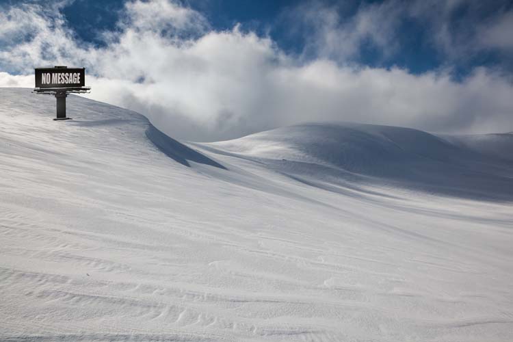
No message

"No message" (5616 x 3744 pixels)

In this image of a standard (14′ by 48′) roadside image in a wilderness snowfield near Mt Kosciuszko, I wanted to make the billboard to itself become visible as an object, rather than as the almost-invisible vehicle for delivery of messages to a mass audience.  In a way it’s a McLuhan-esque effort to put the message to one side and focus solely on the medium.  I also sought to ask two questions of the viewer.

Firstly, if removed from its audience, and relocated in an environment without viewers, what happens to the sign? Does it continue to have meaning? It retains a physical presence and the capacity to express a message – but can it be said to have a message if it has no audience? This resembles the old pop-philosophical question:  if a tree falls in a wilderness forest with no-one there to hear it, does it make any noise?

It could of course be said that the billboard sign does have an audience i.e. us, the viewers of the reproduced photographic image. However we view only a picture of the billboard and its message. It is a ‘sign-within-a-sign’, or a ‘sign-about-a-sign’ i.e. a ‘meta-sign’. It is  at least one degree of abstraction removed from the ‘real’ sign and its message. (In fact it is even less than that, as it is only a contrived Photoshop 3D model of sign,  an ‘object’ which has never had existence in physical space!)

And the second question is: what might this then reveal about the mechanisms by which these objects function in their conventional human environment?

Albany Humpback Whales

During our recent travels in Western Australia there was a heap of great and varied photographic opportunities. (I hope to write a post about some more of them soon …) But one of the real highlights for us was during our time in Albany on the south coast of the state, where you look out into the Southern Ocean and there’s no land between the shore and Antarctica.

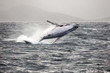
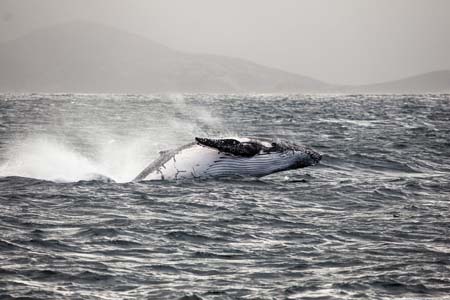
We took a boat out from the port in Princess Royal Harbour into King George Sound to look for whales, which are now in their seasonal migration from the northwest coast of Australia en route to Antarctic waters for the summer. The weather was a bit ‘iffy’, with some heavy rain, winds and some swell as we set out, but it cleared gradually during the course of our journey out across King George Sound past Michaelmas and Breaksea Islands.

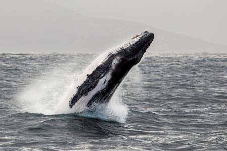
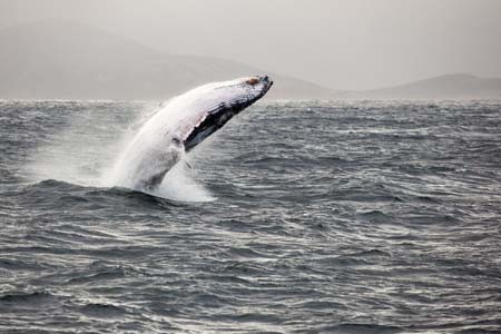
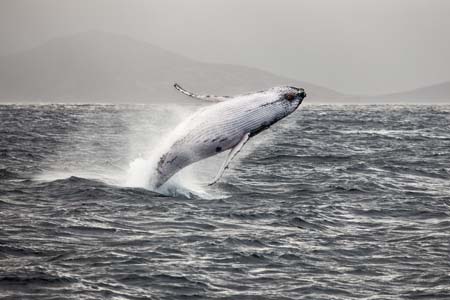
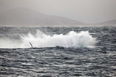
And then we saw the whales. They were jumping (‘breaching’) on all sides of us, probably eight to ten of them. It was hard catch them on the camera, as you couldn’t tell where the next one was going to launch from. I was using the 70-200mm f2.8L lens at ISO 400, f4 and shooting fast (1/3200 second) to freeze them in the air, and counteract the occasional lurching of the boat in the swell. I  also braced myself standing between two stainless steel railings on the boat to keep my balance!

Albany Humpback whale breachingAlbany Humpback whale breachingAlbany Humpback whale breachingAlbany Humpback whale breachingAlbany Humpback whale breachingAlbany Humpback whale breaching

John Woodbury owns the catamaran that we were on, and he takes people out pretty much every day to look for whales during the ‘season’. He reckoned that he’d never seen such a sustained spell of them jumping like that, and this was the first time that he’d had to turn back for port with them still putting on a show.

The next day I gave John copies of some of the photos, which he liked enough to pass them on to a bloke at the local paper, the Albany Advertiser. He in turn he contacted me to ask permission to reproduce them in the paper. I agreed to supply them without charge on condition that I got full attribution and the article included a link to my web site. Always get attribution! The newspaper article is up on their web site at this link.

You can see the full set of whale photos, also including some images of Fur Seals, on the Jokar website in this folder.